The Aleutians Campaign
The Official Navy History of the Only World War Two Invasion of US Soil
Red
and Black Publishers, St Petersburg, Florida
Originally
written 1943, published by Naval Historical Center, Department Of The Navy, Washington DC, 1993
Library
of Congress Cataloging-in-Publication Data
The Aleutians campaign : the official Navy
history of the only World War Two invasion of US soil.
p. cm.
"Originally written 1943, published by Naval Historical Center,
Department Of The Navy, Washington DC, 1993"--T.p. verso.
ISBN 978-1-934941-88-1
1. World War,
1939-1945--Campaigns--Alaska--Aleutian Islands.
D769.87.A4A44 2010
940.54'28--dc22
2010015083
Red
and Black Publishers, PO Box 7542, St Petersburg, Florida, 33734
Contact
us at: info@RedandBlackPublishers.com
Printed and manufactured in the United States of America
Contents
Introduction
5
The
Attack on Dutch Harbor, June 1942 9
Enemy
Occupation of Attu and Kiska 19
“Strong
Attrition”—Kiska Bombarded
23
Occupation
of Adak, 30 August 1942
33
From
Adak to Amchitka, September 1942--January 1943 37
Occupation
of Amchitka, 12 January 1943
41
First
Bombardment of Attu, 18 February 1943 43
Destruction
of Enemy Ammunition Ship, 19 February 1943 47
The
Battle of the Komandorskis, 26 March 1943 51
Second
Bombardment of Attu, 26 April 1943
99
The
Invasion of Attu, May 1943 103
Softening
up Kiska 137
The
Invasion of Kiska, 15 August 1943
147
Conclusion
157
Introduction
Until the end of the Pacific War no one
can make a conclusive statement of the objectives of the Japanese attack on the
Aleutian Islands in June 1942. The enemy may have been planning the subsequent
conquest of all the islands in order to obtain access to Canada and our
northwestern states. He may even have aimed at an immediate invasion of Alaska,
only to be deterred by our victory at Midway. It is well known that the Japanese
had long coveted Alaska and the Aleutians, and that many of their military
leaders considered these poorly defended outposts the logical route for an
invasion of North America.
The enemy’s intentions may have been less ambitious, however. He
may merely have planned to protect his northern flank, to divide our forces, and
to complicate our defense of Hawaii and the West Coast after the expected
capture of Midway.
Whatever his primary motives, the crushing blow administered by our
forces in the mid-Pacific drastically revised the strategic situation. The
reasons why Japan clung thereafter to her footholds in the western Aleutians are
obscure. But it is probable that Attu and Kiska were either to provide
jumping-off places for a future invasion, or to constitute advanced observation
posts and defenses for the Empire. Perhaps both ends were envisaged. At all
events, it was immediately clear that the occupation provided a continuing
threat to our security. Even if this threat did not develop, any plans for
seizing the offensive in the Central Pacific would be difficult to execute while
the enemy maintained his flanking positions in the north. Furthermore,
considering the war as a whole, every day that hostile troops remained on
American soil was as beneficial to Japanese morale as it was deleterious to that
of our own people.
The situation was grave. Because of our commitments elsewhere, the
means of quickly resolving it were far from adequate. As a result, the Japanese
were ejected from the Aleutians only after 15 months of arduous operations which
were hampered by shortages afloat, ashore, and in the air, as well as by almost
insuperable obstacles of weather and terrain.
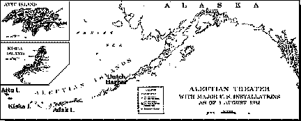
The Geographical Factor
One cannot form an accurate picture of the Aleutians Campaign
without a thorough understanding of the geographical and meteorological
peculiarities of the area. Practically every offensive or defensive move by
either side was conditioned as much by terrain and weather as by the efforts of
the enemy.
Approximately 120 islands comprise the Aleutian chain, which
stretches from the tip of the Alaskan peninsula to within 90 miles of Kamchatka.
The easternmost island, Unimak, is also the largest, measuring 65 by 22 miles.
To the southwest is Unalaska, on the north coast of which Dutch Harbor is
located. Unalaska is about 2,000 miles from both San Francisco and Honolulu.
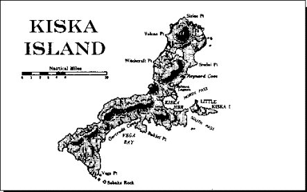
Westward, in order, lie Umnak, Atka, and Adak. Kiska is 610 miles west of Dutch
Harbor, while Attu, the westernmost American island, is nearly 1,000 miles from
the Alaskan mainland and 750 miles northeast of the northernmost of the Japanese
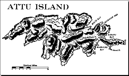
Kurile Islands. Attu is about 20 by 35 miles in size.
Terrain
All the Aleutians are volcanic in origin. They are uniformly rocky
and barren, with precipitous mountains and scant vegetation. The mountains are
conical in shape and covered with volcanic ash and resembling cinders. There are
no trees on the islands, except a few stunted spruces at Dutch Harbor, and no
brush, which complicates the building and heating problems. The lowlands are
blanketed with tundra or muskeg as much as three feet thick. This growth forms a
spongy carpet which makes walking most difficult. Below the tundra is volcanic
ash which has been finely ground and watersoaked until it has the consistency of
slime. In many places water is trapped in ponds under the tundra. Frequently men
have fallen into these bogs and been lost.
Throughout the Aleutians, jagged shorelines and submerged rock
formations render navigation hazardous. Conditions are least unfavorable in the
eastern islands. Unalaska has two comparatively good anchorages, Dutch Harbor
and Captain’s Bay, while Umnak has three, of which Nikolski Bay on the west
coast is the most important. Farther west, protected anchorages are scarce. Atka
has two fair harbors. Adak has three small bays on the west coast. Amchitka
offers one small bay on the east coast. Neither Kiska nor Attu possesses a
harbor which is entirely suitable for larger vessels. Kiska is the better
endowed, having a broad, moderately deep indentation on the eastern shore which
is protected by Little Kiska Island, lying across its mouth. Attu has four less
adequately guarded bays—Holtz, Chichagof, and Sarana on the northeast side,
and Massacre Bay on the southeast. Of these Chichagof is the best.
Weather
Meteorological conditions become progressively worse as the western
end of the island chain is approached. On Attu five or six days a week are
likely to be rainy, and there are hardly more than eight or ten clear days a
year. The rest of the time, even if rain is not falling, fog of varying density
is the rule rather than the exception. Weather is highly localized, however, and
areas of high visibility will often be found within 20 miles of fog
concentration.
Throughout the islands annual rainfall averages 40 to 50 inches,
spread over most of the year. Precipitation is rarely heavy, but reaches a peak
in fall and early winter.
A special hazard to sea and air navigation is provided by sudden
squalls known as “williwaws,” which sweep down from the mountainous area
with great force, sometimes reaching gale proportions within half an hour. The
mountains are concentrated on the north sides of the islands, and the williwaws
cause strong off-shore winds which make it difficult to find a lee along the
north coasts. The columns of spray and mist resulting from the williwaws
frequently resemble huge waterfalls.
Winds generally are gusty because of the deflection of air currents
by the steep mountain slopes. The greatest velocities occur in March. In the
Aleutians, curiously enough, winds and fogs may persist together many days at a
time. Humidity is always high. Temperatures are moderate and not subject to much
variation. In this connection it should be remembered that, contrary to popular
conception, the Aleutians are not arctic territory. In places they are only 02º
north of the border between Canada and the United States proper. Kiska lies in
the latitude of London and the longitude of New Zealand.
While Aleutian weather was a constant impediment to he military
operations of the United States and Japan alike, the enemy enjoyed one
advantage. Weather in this theater moves from west to east, with the result that
the Japanese always knew in advance the conditions which were likely to prevail
in the islands.
Chapter
1: The Attack on Dutch Harbor
June 1942
While the eventual goal of the
Japanese activities in the Aleutians remains somewhat obscure, it is clear that
the initial attack in June 1942 was subsidiary to the powerful thrust at Midway.
The Central Pacific offensive was conducted by approximately 80 ships, including
4 or 5 carriers, at least 3 battleships, and a large number of cruisers,
destroyers, auxiliaries, and transports. The simultaneous assault on the
Aleutians employed a much smaller force, probably containing two small carriers,
two seaplane tenders, several heavy and light cruisers, destroyers, and
submarines belonging to the Fifth Fleet, and from four to six transports and
cargo vessels. Obviously Midway was the primary objective.
The Midway attack was thrown back with great loss in what may prove
to have been one of the decisive battles of the war. In the Aleutians area,
however, the weakness of our forces, plus the ever-present handicaps of climate
and geography, precluded our maintaining an airtight defense. In spite of heroic
efforts, especially those of Army and Navy pilots, it is doubtful whether we
prevented the enemy from attaining any of his immediate objectives, modified as
they undoubtedly were by the Battle of Midway.
Preparations
CINCPAC on 21 May 1942 established Task Force Tare under the
command of Rear Admiral Robert A. Theobald. Admiral Theobald was given control
of all Army, Navy, and Canadian forces in the Alaskan-Aleutian theater and was
ordered to prepare to defend the area against Japanese attack. The inadequacy of
the strength available for this task is well demonstrated by a comparison with
the naval and air forces present in the Philippines in December 1941, since the
results of our weakness in that theater are well know. In the Philippines were
stationed 73 naval vessels, including 3 cruisers, 13 destroyers, and 29
submarines, as well as 280 aircraft of all types. Task Force Tare, on the other
hand, contained only 52 vessels and 169 planes. Its sole advantage was in
cruisers, of which there were 5, 2 heavies and 3 lights. The rest of the naval
force was composed of 11 destroyers, 6 submarines, 2 destroyer seaplane tenders,
1 gunboat, 1 minesweeper, 2 oilers, 10 Coast Guard vessels, and 14 district
patrol craft. Planes, mostly Army types, consisted of 94 fighters, 7
four-motored bombers, 42 two-motored bombers, 23 patrol bombers (PBYs of PatWing
Four), and 3 scouts.
Admiral Theobald’s force not only was pitifully small but it had
to be spread dangerously thin. Nevertheless, our situation at that time was such
that no significant reinforcements could be assigned, although the area to be
protected constituted one of the most important approaches to the United States.
The main surface vessels of Task Force Tare proceeded from Pearl
Harbor to Kokiak. There, on 27 May 1942, Admiral Theobald issued an operation
plan for the several groups under his command, since intelligence had by this
time made it clear that a Japanese attack could be expected during the first few
days of June, probably on the Umnak-Dutch Harbor-Cold Bay area.
Since Task Force Tare contained no carrier, Admiral Theobald was
dependent on land or harbor-based planes for searches. His 23 PBYs were located
principally at Dutch Harbor and Kokiak and were capable of reconnaissance over a
radius of 400 miles. The Army possessed one base farther west, at Fort Glenn on
Umnak Island, which had been constructed in such deep secrecy that it was
believed to be unknown to the enemy. Twelve P-40s were stationed there. These
planes were of slight value for search but were to prove helpful in attacking
Japanese surface forces.
By 1 June the entire coast from Nome to Seattle was in a condition
of 24-hour alert, with aircraft searching to the limit of their fuel endurance
and other planes being hastily ferried in from the south. Great reliance was of
necessity placed on radar installations in patrol planes, not only to prevent
collisions with fog-shrouded mountains, but to make the searches themselves in
any way effective, since the scarcity of aircraft and the poor visibility did
not permit close visual search. Later events proved that this reliance was fully
justified. Until the enemy occupation force was discovered at Kiska, every
contact was made first by radar and later developed visually.
Dutch
Harbor Bombed, 3 and 4 June
On 2 June two enemy carriers were reported less than 400 miles
south of Kiska. All available 11th Air Force planes were immediately
ordered to the advanced airfields at Cold Bay and Fort Glenn.
Aided by the first clear weather in three days, the Japanese
attacked Dutch Harbor and nearby Fort Mears on the morning of 3 June almost
simultaneously with their attack on Midway. In the harbor were the two old
destroyers King
and Talbot,
the destroyer-seaplane tender Gillis,
the submarine S-27,
the Coast Guard cutter Onondaga,
and the U.S. Army transports President Fillmore and Morlen. When
unidentified planes were detected at 0540 by the radar of the Gillis (Lt.
Comdr. Norman F. Garton), she and the other ships weighed anchor and stood out
with all hands at battle stations.
Ashore, the Naval Air Station had gone to General Quarters at 0430
in accordance with daily routine. At 0545, while battle stations were still
fully manned, a flight of about 15 carrier-type fighter planes appeared. Any
doubt as to their enemy character disappeared when they began to strafe our
installations, and our batteries opened an intense antiaircraft fire. After a
single flight over the station, during which they did very little damage, the
planes moved off to the northward.
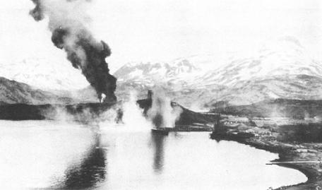
Japanese bombing of Dutch Harbor, 4 June 1942
At about 0550 four bombers approached on a course of 030º. Five
minutes later they released 16 bombs. Two dropped into the water, but 14 fell in
the congested area of Fort Mears, the white frame buildings of which made a
conspicuous target. Two barracks and three Quonset huts were destroyed and
several buildings were damaged by the hits and resulting fire. Approximately 25
men were killed and about the same number wounded. A second flight of three
bombers overshot Fort Mears and did no material damage, but a third flight of
three planes damaged the radio station and demolished a Quonset hut.
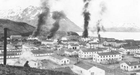
Burning buildings at Ft. Mears after first enemy attack on Dutch Harbor, 3 June
The last flight of planes apparently had as its target the wooden
oil tanks, which had been there for years, so that the enemy could easily have
known their location. The bombs overshot the tanks, but killed a man in a Navy
fire watcher’s pillbox and the driver of an Army truck. All told, about 15
fighters and 13 horizontal bombers participated in the raid. All the bombers
were tracked in at about 9,000 feet. No fighters from Fort Glenn, 65 miles away,
managed to intercept.
The ships (except the Morlen and S-27) had joined the
shore batteries in firing at the planes. The Commander of the Naval Air Station
remarked that “the President Fillmore’s fire was notable. In addition
to her own armament, she had mounted on deck a battery of 37-mm. guns consigned
to Cold Bay, which gave her 22 antiaircraft guns. These were served with such
rapidity that the Fillmore appeared to be (and was reported) on fire.”
The Gillis claimed two planes shot down. No ship was damaged.
The morning of 4 June was rainy and overcast. In spite of the
reduced visibility, our Catalinas kept contact with the enemy force most of the
morning, until a tracking plane was damaged by antiaircraft fire. During the day
the weather improved, and by evening it was clear, with scattered clouds at
3,000 feet.
Damage to Ft. Mears caused by Japanese raid of 3 June
At 1740 Fisherman’s Point Army Observation Post reported three
flights of bombers headed for Dutch Harbor. Shortly before 1800 they were
reported near Mt. Ballyhoo. At 1800 fire was opened as ten fighters attacked the
Naval Air Station in a low strafing attack. Then 11 bombers delivered a
dive-bombing attack through openings in the overcast. Each carried one large
bomb, which was released after a shallow dive to 1,000 or 1,500 feet. The chief
damage was to our four new 6,666-barrel fuel oil tanks, which had been filled
for the firs time on 1 June by the Brazos.
These, with their contents of 22,000 barrels of fuel, were totally destroyed.
The adjacent Diesel oil tank was punctured and burned out, but bunkers
fortunately prevented burning oil from reaching the remainder of the tank farm.
An old station ship, the Northwestern, which had been beached for use as
a barracks for contractors’ personnel, was set afire and partly destroyed. The
Japanese also scored hits on a warehouse and an empty aircraft hangar.
At 1821 three horizontal bombers approached from the northeast.
Their five bombs fell harmlessly into the harbor. The final attack of the day
came at 1825, when five planes, approaching at high altitude from the northwest,
dropped bombs near the magazine area near the south slope of Mt. Ballyhoo. Nine
bombs were ineffective, but the tenth killed an officer and three men in a Navy
20-mm. gun emplacement. Personnel casualties during all the attacks were 33
Army, 8 Navy, 1 Marine Corps, and 1 civilian killed, plus about 50 wounded.
Coincident with the second Dutch Harbor raid, Japanese fighters
strafed shore installations at Fort Glenn on Umnak. Army pursuit planes took to
the air and shot down two enemy aircraft. The remaining seven withdrew without
inflicting damage. Because of the fog and the retirement of the hostile
carriers, many enemy planes probably ended in the sea. As their gas ran low,
frantic radio calls were heard.
The three Japanese attacks on 3 and 4 June constituted the
enemy’s sole offensive action in the central and eastern Aleutians in the
entire period of the campaign. As has been suggested, the outcome of the Battle
of Midway may have caused a change in the plans of the Japanese High Command.
The discovery by the enemy of the air base on Umnak, 600 miles west of Kodiak
and 100 miles west of Dutch Harbor, may also have exercised a restraining
influence.
Meanwhile Admiral Theobald’s main surface force, consisting of
two heavy cruisers, three light cruisers, and four destroyers, was operating in
the Gulf of Alaska about 400 miles southeast of Kodiak Island. This position was
maintained in order to be able to intercept any hostile attempts to land troops
on the mainland or otherwise challenge our shore defenses. Such sightings of
enemy ships as occurred during this period were too far west for an attack by
Task Force Tare, even if Admiral Theobald had chosen to meet the Japanese
without the support of carrier aircraft. On both 3 and 4 June, our search
planes, operating for the most part in extremely bad weather, reported sighting
individual Japanese carriers or carrier groups about 200 miles southwest of
Umnak. Brig. Gen. William O. Butler, Commander of the Air Striking Group of Task
Force Tare, ordered his planes to attack these ships, but because of inaccurate
contact reports and persistently unfavorable weather our bombers failed to
inflict significant damage. Concerned by the course of events, Admiral Theobald
decided to confer personally with his task group commanders at Kodiak, since
enforced radio silence prevented contact with subordinates while at sea. He
therefore departed from the main surface force in the Nashville,
leaving Capt. Edward W. Hanson of the flagship Indianapolis
in command. He started back from Kodiak the next afternoon (the 5th),
after emphasizing the absolute necessity of maintaining the maximum number of
planes in the areas where the enemy appeared to be operating.
Despite reports of occasional successes by Army bombers,
operational and combat losses incurred in keeping contact had become
increasingly serious. On 4 June Admiral Theobald intercepted a dispatch stating
that only 14 PBYs remained operative. Pilots and crews were said to be at the
limit of endurance after 48 hours of continuous operations in bad weather, while
there had been numerous costly encounters between patrol planes and Zeros.
Although it is possible, in view of the low visibility, that the
Army B-26s inflicted more damage than was apparent at the time, and that their
counterattacks from Umnak surprised the enemy and were a factor in the
retirement of his carriers, the situation had deteriorated to such an extent by
7 June that CINCPAC was requested to dispatch a carrier and additional cruisers
to reinforce Task Force Tare. COMINCH suggested using the Saratoga.
Stripping the West Coast of all patrol squadrons was authorized. The Army sent
eight A-29s and four B-17s from Edmonton to Alaska, and six B-24s were ordered
north from California. Later developments, however, rendered the naval
reinforcements unnecessary.